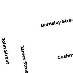
0084 JAMES STREET
Owner Information
YOUNG MICHAEL S & KRISTY L
84 JAMES STREET
ACUSHNET, MA 02743


Property Details
0084 JAMES STREET is classified as a Single Family Residential (Old style).
The primary structure on this property was built in 1957. There are 1,306ft2 of built area within this property. There is 1,306ft2 of residential/living space within this property. This property is listed as having 5 rooms.
0084 JAMES STREET is valued at $243,300. The land is valued at $79,000 and the structures are valued at $162,600. There is an additional valuation of $1,700 on this property.
The most recent deed for 0084 JAMES STREET is recorded at the local registrar in Book 137, Page 7. 0084 JAMES STREET was last sold on Tuesday, September 22, 2015 for $165,000.
Assessment data from fiscal year 2021.
Flood Data
According to the FEMA National Flood Hazard Layer, this property does not appear to be in a flood zone. It may also be in an area not yet reviewed. Nonetheless, confirm this information prior to taking any action.
To view the flood hazards around this property, create a FEMA "Firmette" Map of the area around 0084 JAMES STREET.
Broadband Internet Providers
| Provider | Type | Bandwidth (mbps) | |
|---|---|---|---|
| Comcast | Cable | 1000 | 35 |
| Viasat Inc | Satellite | 35 | 3 |
| VSAT Systems, LLC. | Satellite | 2 | 1 |
| HughesNet | Satellite | 25 | 3 |
| GCI Communication Corp. | Satellite | 0 | 0 |
| Verizon New England Inc. | DSL | 10 | 1 |
Broadband service provider data from December 2020.
Adjacent Properties
- 0011 COULOMBE STREET
Single Family Residential owned by KELLY PATRICK J & NANCY E - 0082 JAMES STREET
Two-Family Residential owned by BROWN JESSICA M - 0015 COULOMBE STREET
Single Family Residential owned by LUSSIER LUCIEN F & BARBARA A TR - 0090 JAMES STREET
Single Family Residential owned by GONSALVES STELLA LIFE ESTATE